Choosing the maps of my study
I chose 4 maps to study as part of the research process with the wonderful team at Mapbox, Bangalore.Arun, Upendra & Rasagya, where more than willing partners in this process. Their love for maps and cartography was visible all the time! We could talk maps for a good 4 hours, and not be bored. I will definitely be visiting them again soon.
How I researched my sample maps.
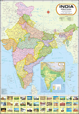
1) Political Map of India. A map of the sort that I remember from my Geography book in school. It would be unfair to compare this map though, as a Political map has very clear requirements. However, I felt this Map has many things missing, and thought it would be interesting to get an expert opinion on it.
The maps were chosen after much deliberation. After repeated failed searches on the Internet, I found that most maps for children use iconography, are too crowded or are too simplistic. There was never a perfect map. But many maps had elements that worked well. As the study is about what makes a perfect map for kids, and what can be improved, I chose -


2) A Map of India from 1934! This map was a rather rare find. It is a pre-independence map of India by Tata Airlines, tracing the routes of the flight. It also adds interesting little bits about each place of prominence like the crafts, the industries etc. It also gives a sense of distances between places.
3) Maps Of Bangalore - I wanted expert opinions on my own skills as a Children's map designer, so I used 2 of my hand-drawn maps to see what works and what doesn't from an expert space. Both these maps are also neighborhood maps, which is still a nascent idea for kids in our country. I thought this might be an interesting idea to present and to draw attention to.
Map 3 of Cooke Town
Map 4 of Tipu's Bangalore
Armed with these research samples, I landed up and Mapbox on a rainy Friday evening. We used free flow discussions, observations, and made connections between various maps. Then I used the tool See. Think. Wonder on each of these maps.
The next post will be on how the tool was used, and the discussions we had around our findings from it.


Comments
Post a Comment